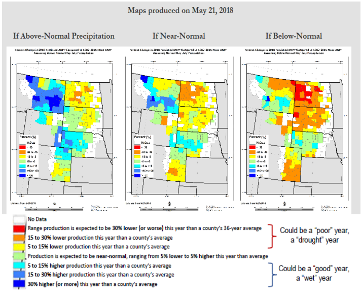
South Dakota Grassland Coalition

By Sandy Smart

March 2021

introduction

Drought is a relatively common occurrence in the central and northern Great Plains. Spring drought (April-June) occurs 19-35% of the time in our region (see Smart et al. 2021 “Forum: Critical Decision Dates for Drought Management in Central and Northern Great Plains Rangelands” open access article in Rangeland Ecology and Management). Spring droughts are particularly troublesome because most of our forage production comes from cool-season grasses. Summer droughts have less impact on pasture production but can result in lower crop yields.

The Grass-Cast Tool

Every good drought plan has key trigger dates that incorporates 1) past, current, and forecasted climatological information; 2) livestock and feed market information, 3) rangeland vegetation monitoring; and 4) a suite of management actions to bring balance between livestock demands and forage supply. The hardest part about “pulling the trigger” in the drought plan is having confidence in making the right decision. No one has a crystal ball to look into the future to have 100 percent certainty, however past experience and a buildup of scientific information and recent technological advancements can provide us with the necessary tools to make good drought management decisions.

One of those technological advancements is the new grassland productivity forecast tool called “Grass-Cast” (available online at https://grasscast.unl.edu/). This collaborative effort by USDA Agricultural Research Service, Colorado State University, National Drought Mitigation Center, University of Arizona, and the USDA Northern Plains Climate Hub provides forage productivity maps at the county level for the Great Plains and the Southwest USA. Starting on May 1st maps are generated for the upcoming growing season. The maps are updated every two weeks and to adjust seasonal estimates as more weather data is added to the models. In South Dakota, April through June rainfall is critical to producing forage on range and pasture. Since most ranchers turn out livestock on pasture in early to mid-May, having a reasonable estimate of grass production by then would be extremely helpful. By July 1st, most of the annual forage production has occurred; so waiting for rain won’t help much. Thus the best use of Grass-Cast will be in May and June.

Using Grass-Cast

Grass-Cast shows three options or “what if” (above-normal, near-normal, and belownormal) precipitation scenarios. The maps produced on May 21, 2018 (shown on page 3 of the newsletter) give equal chances (33%) for each scenario. The red, orange, and yellow colors on the map indicate below-average forage production compared with the county’s average; green, teal, blue, and dark blue colors indicate above average forage production. As interpreted, the colors that indicate below-average for-age production dominate two out of the three maps. Only the “above-normal” precipitation map shows adequate forage production for western South Dakota.

MAPS ARCHIVE

A nice feature on the website is the “Maps Archive” tab. Here you can see the previous predictions and compare them to the most current set of maps.

Drought preparedness starts with a plan. Having a reliable estimate of forage production is critical for making decisions. Grass-Cast can be used as one component in your drought plan. Overtime, like anything else, we should see improvements in forecasting. It would be a good idea to make notes of forage production on your own ranch so you have some benchmark to make comparisons. For more information on drought planning visit the National Drought Mitigation Center (http://drought.unl.edu/) or contact your local range extension field specialist.

Join our Mailing list!

Get all latest news & be the first to know about upcoming events.